bajfsdojfsdajfklasdjsssssssssssssssssssssssss                                                ssssssssss      s33ssssfklsdjfkCentral Ohio Air Quality 

For optimum phone homepage use landscape/turn sideways

Browser Menu To access use portrait

  • Vision

    Vision

    The Vision Statement guides Ashville. Council meetings start at 6:30 pm on the 1st & 3rd Monday of each month. Schedule: http://www.ashvilleohio.gov/index.php/village-government. Click on the Banner or Read More for Tribute Information for Mayor Wise. Read More
  • 2023 Consumer Confidence Report

    2023 Consumer Confidence Report

    2023 Consumer Confidence Report Read More
  • Alerts & Advisories

    Alerts & Advisories

    Go to http://local.nixle.com/zipcode/43103/ municipal/ or click on the Banner or Read More. Read More
  • Planning & Zoning Project

    Planning & Zoning Project

    The Village of Ashville with Crossroads Community Planning is updating its Planning & Zoning Codes. For more information click on image or "read more". Read More
  • Projects

    Projects

    Access information on projects for parks, streets, & utilities by clicking on the Banner or Read More. Please note that some projects may span years or may involve a combination of Ashville services. Read More
  •  Water Facility Project

    Water Facility Project

    Information about this project is found by clicking on the Banner or Read More. The webpage was developed to track and provide transparency to this process. Read More
  • Water Tower Project

    Water Tower Project

    The Village of Ashville is working on replacing the Cromley Water Tower with a North Water Tower. Click on read more or the banner for more information. Read More
  • Water Connection Projects

    Water Connection Projects

    Information about these projects are found by clicking on the Banner or Read More. Earnhart Hill & South Bloomfield(Completed) Water Connection. The webpage was developed to track and provide transparency to this process. Read More
  • Phase II of the State Route 316 Project

    Phase II of the State Route 316 Project

    The Phase II State Route 316 Project is from Station Street to SR 752. Click on Read More of the Banner to access more information. Read More
  • 2024 & 25 Paving Project

    2024 & 25 Paving Project

    Summary information on 2024 Randolph Street Paving Project. For more detailed information you can be linked to the project webpage by clicking on the Banner to the right or Read More Read More
  • Water Resource Recovery Facility Expansion

    Water Resource Recovery Facility Expansion

    Information about this project is found by clicking on the Banner or Read More. The webpage was developed to track and provide transparency to this process. Read More
  • Westside Park Project

    Westside Park Project

    Submitted Westside Park in 2022 and in 2024. Click on image or read more for Information. Read More
  • Park

    Park

    Information on Ashville Park development can be found by clicking on the Banner or Read More. We have been fortunate to benefit from Pickaway County Park District funding. Read More
  • Pedestrian Project

    Pedestrian Project

    Ashville & ODOT is funding a Pedestrian Enhanced Intersection Improvement Project. The intent is to add two (2) pedestrian signals and five (5) LED street lights. For more information click on the Banner or Read. Read More
  • South Metershed Project

    South Metershed Project

    Phase 1 of Improvement Project is funded by the Ohio Public Works Commission & the Ohio Department of Development (American Rescue Plan Act of 2021) for funding. For information click on the Banner or Read More. Read More
  • Resource Connection

    Resource Connection

    Resource information can be found by clicking on the Banner or Read More. This information includes transportation, food, computers, & connectivity, If you have an idea or information, please let us know. Read More
  • Financial Page

    Financial Page

    Financial ReportsThese reports include the Temporary and Permanent Expense Budgets, Anticipated Sources of Revenue Budget, Annual Financial Reports of the village and other financial information. Read More
  • CCR

    CCR

    Water Quality Report is also know as the Consumer Confidence Report (CCR). You can take a look at the report (s) by clicking on the Banner/Read More. Read More
  • Gas Aggregation

    Gas Aggregation

    Gas Aggregation is through Constellation NewEnergy - Gas Division, LLC. This was authorized by Ballot Question, legislation, & contract. For those documents, updates, & past information click on the Banner or Read More. Read More
  •  Ashville Foundation

    Ashville Foundation

    The purpose is to review its history, recruit members, elect officers, and approve by-laws. We encourage you to click on the Banner or Read More to get involved. Read More
  • Reporting Potholes

    Reporting Potholes

    If you see a pothole please call 740-983-6367 and report the location. To find out more about reporting potholes in Ashville, click the Banner or Read More. This will take you to our online reporting system. Read More
  • General Information

    General Information

    By clicking on this Banner or Read More you will find out more information on projects, events, and more. Read More
  • 1
  • 2
  • 3
  • 4
  • 5
  • 6
  • 7
  • 8
  • 9
  • 10
  • 11
  • 12
  • 13
  • 14
  • 15
  • 16
  • 17
  • 18
  • 19
  • 20
  • 21
  • 22

Village of Ashville, Ohio

Out in the Field - Finding and Fixing I&I

How do you find I & I?

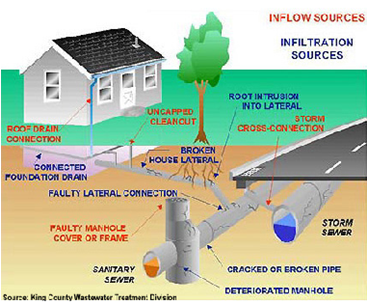
I & I is a result of groundwater or stormwater that flows into the sanitary sewer system due to leaky sewer lines or manholes or from situations where storm water can flow into the sanitary sewer system through direct connections, such as catch basins or roof drain connections. While there are two general approaches to finding and dealing with I & I, there are a variety of methods to determine if and where the problems are located.

Proactive Detection - Sewer System Evaluation Surveys (SSES)

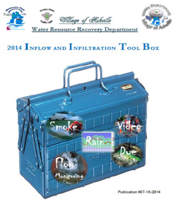
Several sewer system tests can be used to examine the condition of individual sewers and identify I & I sources. These proactive detection tests are called sewer system evaluation surveys. A few of these tests include:   

Smoke Testing portions of the sanitary sewer pipes involves pumping smoke through sanitary sewers from utility holes in streets or within public easements and observing and documenting where smoke exits. Depending on the specific circumstances, the exiting smoke can indicate the location of a broken pipe, manhole, catch basin, or where roof or foundation drains might be connected to the sewer system, indicating where I & I inflow might enter the sanitary sewer system.

Dye Testing: By using a fluorizine dye, inappropriate connections can be determined. For instance, if a dye is introduced to a catch basin and the dye is then observed in the sanitary sewer downstream from that point, the evidence would indicate that that catch basin is directly connected to the sanitary sewer system.

TV Inspection: Recording conditions using a TV camera within the pipes. Closed Circuit TV (CCTV) cameras have been developed that can be slid down sanitary sewer lines and record a "movie picture" of the conditions that are found in that section of sewer. This can identify breaks, root intrusion, leaking water (especially infiltration from groundwater), and general deteriorating conditions. Estimates can be made for how much infiltration might occur from such leaks.

Flow Monitoring: Open channel flow monitors are used to gather sewer hydraulic information and are installed in manhole locations. Flow metering of the system provides the technical framework upon which a successful I & I program is built. This program will verifying the size and location of local collection systems, modeling and mini-basin configuration, flow meter location approval, traffic control and safety plans, permitting, and fieldwork scheduling.

Rainfall Monitoring: The accurate measurement and reporting of rainfall quantities is necessary to provide a credible basis for the flow data. The team will utilize the rainfall data collected from  rain gauges located throughout Ashville. The collected rain gauge data will be input and utilized to generate accurate rainfall quantities in the I & I control program area.

Passive Detection:  Finding I & I through passive detection methods is a process of observing and noting where sewer flow problems occur. A prime indicator of I & I problems can be identifying where sewage flow backs up in the sewer system. Such backups can occur at sewage treatment facilities or in homes or businesses through drains, toilets or sinks, because a surcharge occurs in the sanitary sewer line. A surcharge is where sewage flows full in a sewage pipe and creates a pressure condition inside the pipe. This situation can force water back upstream, including up sewer lines and out openings in homes and businesses. Sewage flows can also back up and fill manholes to overflowing, resulting in untreated sewage flows being released to the environment causing potential environmental and public health concerns. The I & I Control Program is intended to reduce the incidence of this occurring.

Ashville is designing an I & I program to: meter and identify I & I in the overall system; determine cost effective I & I options & removal methods; and ultimately design a long-term control program for I & I.

The Service Department can affectively keep our streets clear this winter with your help.

When plowing streets and applying salt, the staff is monitoring vehicle location, pedestrian traffic, and the truck with its equipment. Therefore, they are encountering very hazardous conditions and need no additional distractions to the job they are performing.

Since we are likely to have more snow, the following  items would help the process of snow removal:

  • Remove cars from the street. The biggest hindrance to snow plowing and spreading of salt is the presence of vehicles parked on the street.
  • Do not pass a snowplow in the village and stay back a safe distance. Let the snowplow drivers concentrate on clearing the roadway. A driver has to watch the roadway and confirm the salt spreader is working, raise and lower plow blades, and drive the manual transmission truck besides driving through a snowstorm.
  • Improve visibility - Like other big trucks, snowplows have poor visibility on the sides and behind the vehicle. Remember that if you can’t see the driver’s side mirrors, he or she can’t see you.
  • Avoid driving into a snow spray cloud that is created by the plow, which could result in a total “white out” with zero visibility.
  • Pile or blow the snow into your yard. It is best to remove the snow as early as possible to prevent the buildup of ice or packing of the snow. Residents are also asked not to shovel or blow snow from driveways or sidewalks into the street. This can create hazardous conditions and is prohibited by ordinance.

Another area involves sidewalks.

  • Clear off your sidewalk(s), it can be an inconvenience to pedestrians or potentially create a hazard if an ice-patch results. Children need to be able to safely walk to school and to protect pedestrians from possible injury. Residents are required by ordinance to clear sidewalks (including crosswalks) within 24 hours after the end of a snowfall. Watch out for snowplows. If your sidewalk is icy, please apply salt to melt the ice or sand for traction.

If you have questions or wish to report information please contact:

This email address is being protected from spambots. You need JavaScript enabled to view it.

or call 983-6367

Salt for our roads costs $135/ton, and every time we plow we use from 8 to 15 tons of salt. That equates to $1,350 to $2,025 per application.

Please use extra caution when driving near snow plows. Refrain from passing any snow plow until the plow vehicle stops or turns. If you do decide to pass, make sure there is a clear path to do so. Visibility may be impaired by blowing snow or other winter conditions.  Avoid driving into a snow spray cloud that is created by the plow as this may cause a total “white out” of zero visibility to the driver.

While we do not have specialized plows, the following may help you while you drive in areas the do. Motorists should use extra caution when driving near wing plows, which have a regular 12 foot plow in the front and a 9 foot wing plow that hangs to the right. This wing plowing system clears either the driving lane and shoulder lane or two lanes of traffic in one pass. This also means it can be extremely dangerous for motorists who try to pass the plow. One plow may be following another to clear a better path. The bottom line is use care when driving even if you are impatient because a plow operates at a slower speed.  There is a reason for the slower speed, your safety.

Chapter 905.01 SNOW REMOVAL POLICY

by Ashville's Services Department

Updated 11/1/2023 Since the Leaf Vac Machine is down, please note that Local Waste Services will removed bag leaves on Monday during their weekly pick-up.

As part of the Service Department duties, we provide leaf pick-up. This service will begin the last week of October and will end the last week of November, timing driven in large part by weather.  The village usually conducts trial runs to check equipment before the start date.
NOTE:
  Leaves must be taken to the street. Schedule may be changed due to inclement weather or reasons beyond our control. Leaves piled in front or back of vehicles will not be picked 

weather-may-alter-scheduleup—we use the ten (10) “foot rule” to prevent damage.

No brush or flowers will be picked up. Local Waste Services will take limbs that are bundled or weeds (flowers) that are bagged.

The size of our equipment prevents us from traveling in alleys.

If you need to reach the Chief of the Service Department call the Administrative Office at (740) 983–6367 and ask for Greg Sturgill. He will return your call.

leaf machine

The Leaf Vac Machine being operated by the Service Department Gary, Buskirk, Jon Smith, Reed Sommerville, and Greg Sturgill.

This page has been revised to reflect the Infiltration and Inflow (I&I) Plan submitted to the OhioEPA as a result of the Director's Final "Finding & Orders"

ii-plan
 
ii-toolbox
 

ii timeline

Letter One to OhioEPA Letter Two to OhioEPA Plan Summary

Click on Image to the right for the OhioEPA Quarterly Reports on I & I.

Follow this image on that webpage.

i i logo

What is I & I?

I & I is clean storm and/or groundwater that enters the sewer system through cracked pipes, leaky manholes, or improperly connected storm drains, down spouts and sump pumps. Most inflow comes from storm water (rain) and most infiltration comes from groundwater. I & I affects the size of the Village of Ashville’s delivery and treatment systems and, ultimately, the rate businesses and residents pay to operate and maintain them. In extreme water flows Sanitary Server Overflows (SSO) were used to provide relief to Walnut Creek. We had at one time three (3) functioning SSO’s. The last Village of Ashville SSO was eliminated in mid 2007. Before that took place we spent twelve (12) months monitoring that location for any overflow. Please see definitions below.stormwater-i-i

Infiltration

The first I, Infiltration, is groundwater, or groundwater that is influenced by surface water that enters sewer pipes (interceptors, collectors, manholes (MH), or side sewers) through holes, breaks, joint failures, connection failures and other openings. Infiltration quantities often exhibit seasonal variation in response to groundwater levels. Storm events can trigger a rise in groundwater levels and increase infiltration flows. The highest infiltration flows are observed following significant storm events or following prolonged periods of precipitation. Since infiltration is related to the total amount of piping and appurtenances in the ground and not to any specified water use component, it is usually expressed in terms of the total land area being served, or in terms of the lengths and diameters of sewer pipe. The unit quantity used in this study is gallons per acre per day (GPAD).

Inflow

The second I, Inflow is surface water that enters the wastewater system from yard, roof and footing drains, from cross-connections with storm drains, downspouts, and through holes in manhole covers. Inflow occurs as a result of storm events such as rainfall, snowfall, springs or snow melt that contribute to excessive sewer flows. Inflow can also occur in sewer pipes or facilities that are subject to excessive sewage flows due to direct or indirect connections to a water body or operational inflows such as water system connections for sewer cleaning. Peak inflow can occur during heavy storm events when storm sewer systems are surcharged, resulting in hydraulic backups and local ponding.

Steps to Correct I&I

Project Dry Basement

Link to Project Dry Basement


 Facebook Logo roundeddownloadphone-png-clipart-phone-icon-clipart-best-clipart-best-image-949-800.png

Govt/Employee Login